Milan
Showing 1–12 of 70 results
-
Out of stock
An uncommon map of Europe in the shape of a Queen after the same image published by Munster in 1588. Europa as Queen is the map-like depiction of the European continent as a Queen. Made popular in the 1500s, the map shows Europe standing upright, with the Iberian Peninsula forming her crowned head, and Bohemia her heart. During the late 16th Century, a few map makers created these really interesting map images, wherein countries and continents were given human or animal forms. This example was published in Cosmorama Pittorico, Milan 1850. The description on verso explain, curiously, that the Singolar Carta d’Europa (strange map of Europe) shows surely King Charles V.
- Dimension: 10,5 x 17 cm
- Place of publication: Milan
- Year: 1850
-
Out of stock
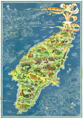
Pictorial map of Rhodes, the island of the sun or rose island in Greece by Egon Huber. Published by Ente Nazionale del Turismo Italiano in Milan at Pizzi & Pizzi, 1935. Shows roads, woods, forts, lighthouses, people in various recreational activities, etc. Also shows buildings, landmarks, ships and boats in white over blue sea. On verso 14 photos of Rodi as well as rich information about Rodi island. The list of the photos: “La citta…
- Dimension: 46,5 x 67 cm
- Place of publication: Milan
- Year: 1935
-
Elegant Italian map by Filippo Naymiller showing The Netherlands published in Milan. Includes a second sheet of text embellished by vignettes of Amsterdam and Brussels engraved by Baldi. It provides really interesting geographical and statistical information of the Countries. The map was finely engraved by Pietro Allodi. From Atlante di geografia universale: cronologico, storico, statistico e letterario Milan, 1860 at Litografia Pagnoni.
- Dimension: 32 x 42 cm
- Place of publication: Milan
- Year: 1860
-
Rare copper engraving with original (uncommon) color. From “Piante delle citt , piazze e castelli fortificati…dello Stato di Milano” by G.B. Sesti published in Milan in 1707. Sold with a second leaf with the description of the town. [cod.337/15]
- :
- Dimension: 195 x 150 mm
- Place of publication: Milan
-
A lovely pocket atlas of the world with text by Annibale Giglioni published in 1886 by Francesco Vallardi. With 12 colorful maps with the description of the continents, the various parts of Italy and the Globe, with indications of the races and languages spoken. See Geoffrey King Miniature Maps 1886b: “This oblong paperback is a rare item today. There is a copy located in the Biblioteca Nazionale Centrale di Firenze, where it is catalogued under…
- Dimension: 10,5 x 15,5 cm
- Place of publication: Milan
- Year: 1886
-
Out of stock
Delizioso atlantino storico dedicato ai fanciulli che mostra, con l’ausilio di curiose piccole carte geografiche traforate, la storia delle suddivisioni territoriali dal 1848 al 1929. Edizione speciale a cura della Società Unica di Torino. Edito a Milano nel 1930 da Giovanni De Agostini.
- Dimension: 23 x 15,5 cm
- Place of publication: Milan
- Year: 1930


