Padova
Showing 1–12 of 20 results
-
Fascinating map of Africa and the Arabian Peninsula based on Ortelius and engraved by Girolamo Porro for “Geografia di Claudio Tolomeo” by Giovanni Antonio Magini published in Padua, 1621. The rivers of central and north Africa feature prominently including the Ptolemaic concept of the origin of the Nile in two lakes south of the Equator. The largest of these lakes also has a river flowing southeast.
- Year: 1621
- Dimension: 14 x 18 cm
- Place of publication: Padova
-
Fine map by Giovanni Antonio Magini engrave day Girolamo Porro based on Giovanni Lorenzo d’Anania’s 1582 map of the Americas and further based on the geography of Ortelius. Most notable is the characteristic bulge to the west coast of South America and the huge Southern Continent that attaches to Nova Guinea. Anian and Quivira appear on North America’s bulbous western coast. From Geografia di Claudio Tolomeo published in Padua in 1621 at Galignani.
- Year: 1621
- Dimension: 14 x 18 cm
- Place of publication: Padova
-
View of the town from “Itinerario overo decrittione de’ viaggi principali in Italia” by Francesco Scoto published in Padua by Matteo Cadorin in 1670. [cod.242/15]
- Year: 1670
- Dimension: 120 x 171 mm
- Place of publication: Padova
-
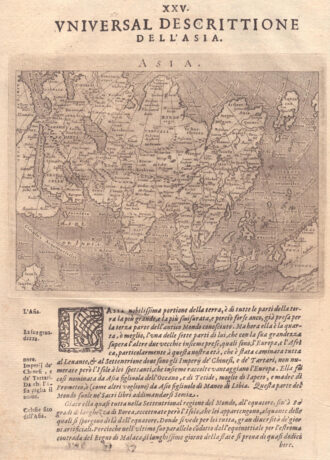
Fascinating map of Asia based on Ortelius’with the exception of the addition of a strait dividing the southern portion of the Malay Peninsula. Interesting depiction of Japan, no sign of the Korean Peninsula. Includes region south of Nova Guinea that is marked as Terrae Incognita Australis, separated from Nova Guinea by a narrow channel. Engraved by Girolamo Porro for “Geografia di Claudio Tolomeo” by Giovanni Antonio Magini published in Padua, 1621.
- Year: 1621
- Dimension: 14 x 18 cm
- Place of publication: Padova
-
Rare copper engraving of the town from “Theatro delle citta’ d’Italia, con nova aggiunta” by Pietro Bertelli, pubblished by Francesco Bertelli in 1629. [cod.1146/15]
- Year: 1629
- Dimension: 116 x 176 mm
- Place of publication: Padova
-
Out of stock
Detailed town plan of walled city of Bologna and surrounding countryside. Includes coat of arms. From the Padua edition of Francesco Scoto’s Itinerario d’Italia. Names major buildings, churches, etc. [cod.214/15]
- Year: 1670
- Dimension: 175 x 120 mm
- Place of publication: Padova
-
Fascinating map of Europe Asia based on Ortelius’ engraved by Girolamo Porro for “Geografia di Claudio Tolomeo” by Giovanni Antonio Magini published in Padua, 1621.
- Year: 1621
- Dimension: 14 x 18 cm
- Place of publication: Padova
-
Out of stock
Detailed town plan of walled city of Ferrara as surrounded by the Po River. Includes coat of arms. From the Padua edition of Francesco Scoto’s Itinerario d’Italia. Names major buildings, churches, etc. [cod.239/15]
- Year: 1670
- Dimension: 175 x 122 mm
- Place of publication: Padova
-
Rare copper engraving of Fondi from “Theatro delle citta’ d’Italia, con nova aggiunta” by Francesco Bertelli published in 1629. [cod.328/15]
- Year: 1629
- Dimension: 120 x 175 mm
- Place of publication: Padova
-
Rare copper engraving of Caiazzo from “Theatro delle citta’ d’Italia, con nova aggiunta” by Francesco Bertelli published in 1629. [cod.495/15]
- Year: 1629
- Dimension: 120 x 174 mm
- Place of publication: Padova
-
Out of stock
Rare copper engraving of Gallipoli from “Theatro delle citta’ d’Italia, con nova aggiunta” by Francesco Bertelli published in 1629. [cod.459/15]
- Year: 1629
- Dimension: 120 x 175 mm
- Place of publication: Padova
-
Rare copper engraving of Lucca from “Theatro delle citta’ d’Italia, con nova aggiunta” by Francesco Bertelli published in 1629. [cod.275/15]
- Year: 1629
- Dimension: 113 x 170 mm
- Place of publication: Padova


