Rome
Showing 1–12 of 24 results
-
Out of stock
Divertente planisfero disegnato da Luigi Roveri e Giuseppe Orliani per la compagnia aerea Alitalia e pubblicato a Roma nel 1975 presso l’editore Daniele Cerretti. Destinata all’infanzia questa carta geografica-pittorica ben si fonde con lo stile grafico degli autori che avendo collaborato per la rivista Miao, nota per le sue storie senza testo, riesce a descrive in maniera sintetica ma riuscita i costumi e le peculiarità delle varie aree del mondo. Luigi Roveri è stato un…
- Dimension: 43 x 65 cm
- Place of publication: Rome
- Year: 1976
-
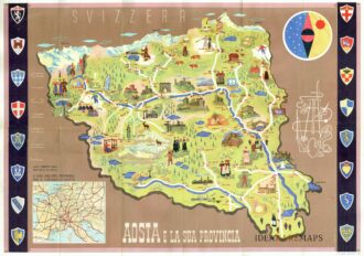
Manifesto pubblicitario che mostra disegno della Valle d’Aosta con monumenti e figure in abiti tradizionali affiancato da oggetti e monumenti tipici del territorio. In alto a destra figura allegorica e stilizzata delle tipicità della regione con fucile, sci, racchetta da tennis, picozza, corda e macchina fotografica. In basso a sinistra riquadro con carta del nord Italia e lungo i lati successione di otto stemmi per parte. Al verso fotografie di diverse località ed un testo illustrativo delle caratteristiche della Valle d’Aosta. Pubblicato dall’Ente Nazionale Industrie Turistiche presso lo stampatore Pizzi & Pizio nel 1937-38. Confronta Collezione Salce, Museo Nazionale 05165
- Dimension: 48 x 68 cm
- Place of publication: Rome
- Year: 1937
-
Out of stock
Maestosa grande mappa geo-pittorica dell’Italia disegnata nel 1965 da Otto M. Muller e V. Clementi per l’istituto cartografico Italiano con sede a Roma in via Alessandro Severo. Il titolo “Carta Ideografica D’Italia” specifica immediatamente che lo scopo della mappa è quella di mostrare la penisola attraverso l’immediatezza dei simboli grafici (ideogrammi) piuttosto che con le classiche rappresentazioni fisiche o politiche. La scelta rendeva immediatamente accessibile l’opera anche agli stranieri i quali erano forse i destinatari…
- Dimension: 100 x 140 cm
- Place of publication: Rome
- Year: 1965
-
Out of stock
A spectacular and rare bird’s eye view of the city of L’Aquila. Title at upper centre, key in a cartouche surmounted by the arms of the dedicatee, Fernando de Casteo, Conde de Lemos, at left, arms of L’Aquila at upper right corner, royal arms of Spain, arms of the dedicator Blas Pico. Lauro was an acomplished Roman engraver. Amongst other works he is particularly known for his Antiquae urbis splendor, a four volume work dedicated … [cod.1064/15]
- Year: 1600
- Dimension: 515 x 385 mm
- Place of publication: Rome
-
Copper engraving from “Il nuovo itinerario d’Italia…” published in Rome in 1699 at P.Rossi. [cod.314/15]
- :
- Dimension: 120 x 172 mm
- Place of publication: Rome
-
Detailed town plan of walled city of Ferrara as surrounded by the Po River. Includes coat of arms. From the Rome edition of Francesco Scoto’s Itinerario d’Italia. Names major buildings, churches, etc. [cod.240/15]
- :
- Dimension: 180 x 122 mm
- Place of publication: Rome
-
Globo Terrestre Delineato Sulle Ultime Osservazioni….del Cap. Cook / Globo Celeste Calcolato …. sulle Osservazioni del Sigg. Flamsteed
More Info € 9.000,00A complete set of gores (12 sheets) for a pair of globes, including calottes and printed matter for the horizon and meridian rings. The terrestrial gores show the tracks of all three of Cook’s voyages, along with his discoveries. The celestial gores, based on the observations of Flamsteed and Lacaille, are beautifully engraved and colored using the traditional, pictorial symbols for the constellations. Bound in original binding with frontispiece of Cassini’s famous work “Nuovo Atlante…
- Year: 1790
- Dimension: 320 x 490 mm
- Place of publication: Rome
-
Out of stock
Detailed map by Giacomo Cantelli covering the Austrian and Italian Alps / Dolomites, including Vorarlberg, Tyrol, Trento, Alto Adige, South Tyrol, eastern Switzerland including Graubünden. Lake Constance is located in the north-west corner of the map, and Lake Como in the south-west corner. The map extends as far east as Zell am See. From Rossi’s Mercurio Geografico published in Rome, 1691.
- Dimension: 44 x 56, 5 cm
- Place of publication: Rome
- Year: 1691
-
Out of stock
A wonderful and rare poster promoting tourism in Italy, showing the peninsula as a perspective view and with very interesting annotations highlighting the moments, the productive activities, the new resources, the social and economic changes that allowed Italy to recover after the Second World War. Designed by Arti Grafiche Menaglia and published in Rome in 1956 by the Ministry of Foreign Affairs for the Italian Embassy in the United States based in New York.
- Dimension: 100 x 70 cm.
- Place of publication: Rome
- Year: 1956


