Fine map by Giovanni Antonio Magini engrave day Girolamo Porro based on Giovanni Lorenzo d’Anania’s 1582 map of the Americas and further based on the geography of Ortelius. Most notable is the characteristic bulge to the west coast of South America and the huge Southern Continent that attaches to Nova Guinea. Anian and Quivira appear on North America’s bulbous western coast. From Geografia di Claudio Tolomeo published in Padua in 1621 at Galignani.
America
- Author: MAGINI Giovanni Antonio – TOLOMEO Claudio
- Year: 1621
- Dimension: 14 x 18 cm
- Place of publication: Padova
€ 350,00
Related products
-
Lovely postcard showing the meeting at Panama between the Pacific and Atlantic oceans as a kiss. Published by Curt Otto Teich in 1935 for Sucesion de Maduro a hats and parfumes shop in Panama. Curt Teich who immigrated to the United States from Lobenstein, Germany, in 1896, founded the Curt Teich Company of Chicago, which operated from 1898 to 1978 as the world’s largest printer of view and advertising postcards.
- Author: Curt Teich
- Dimension: 90 x 140 mm
- Place of publication: Chicago
- Year: 1935
-
An exceptional 1932 bird’s eye view map of the city of Quebec, Canada by Samuel Herbert Maw. The densely filled map displays parks, buildings, named streets and historic notations embellished by numerous coats of arms and a large compass rose. Born in England, Maw was an architect, delineator, etcher, cartographer and designer. After winning the Sloane Medallion from the Royal Institute of British Architects in 1905 and showing at the Royal Academy in London in…
- Author: Samuel Herbert Maw
- Year: 1932
- Dimension: 850 x 650 mm
- Place of publication: Toronto
-
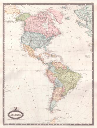
Interesting map of America with high detail and beautiful decorative colouring. The Panama Canal has not yet been built. Colombia is “Nouvelle Grenade” and Alaska is “Amerique Russe”. Much of the Amazon is labeled as “Selvas”, or tropical rainforests, and “Région Inconnue”. From Atlas Spheroidal et Universel de Geographie by M.F.A. Garnier published in Paris at Veuve Jules Renouard in 1862. This atlas is exceptional for its “spheroidal” maps of the globe, showing the various…
- Author: Francois-Adrien Garnier (1799-1863)
- Year: 1862
- Dimension: 680 x 510 mm
- Place of publication: Paris
-
The very fine and interesting map shows the boundaries of the US immediately prior to Texas claiming its independence. Many Indian Tribes and early forts noted. Insets of Texas and St. Pierre Miquelon. From Atlas Spheroidal et Universel de Geographie by M.F.A. Garnier published in Paris at Veuve Jules Renouard in 1862. This atlas is exceptional for its “spheroidal” maps of the globe, showing the various continents and poles, shaded to give the effect of…
- Author: Francois-Adrien Garnier (1799-1863)
- Year: 1862
- Dimension: 340 x 500 mm
- Place of publication: Paris


