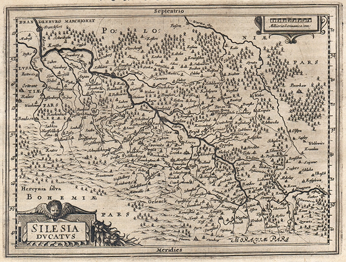
Charming map of the Silesia region with Breslaw (Wroclaw) at center from the Mercator Hondius “Atlas Minor” published in Amsterdam in 1648 at Jannsonius with german text on verso. In 1607 Jodocus Hondius published a reduced size version of Mercator’s “Atlas”, itself suitably titled “Atlas Minor”. The maps were copied from those of the great cartographer Mercator of around 1580-90 or were reductions of Hondius’ own maps of 1606. Almost 20 years later Joannes Janssonius commissioned a new set of copperplates to be engraved by Pieter Van Den Keere (Kaerius) and Abraham Goos. These maps were elegantly designed with decorative title cartouches, finely engraved and surprisingly detailed for their dimensions. Koeman “Atlantes Neerlandici” Me203.
[Poland] Silesia Ducatus
- Author: MERCATOR Gerard - HONDIUS Henricus
- Year: 1648
- Dimension: 190 x 145 mm
- Place of publication: Amsterdam
€ 140,00
Related products
-
Lovely map of Hungary engraved by Elias Baeck from Der curiose und .. Nussliche Dollmetscher.. published in Augsburg in 1748. The map has a decorative cartouche and nice original colours.
- Author: ERDMAN MACHENBAUER J.A.
- Year: 1748
- Dimension: 245 x 160 mm
- Place of publication: Augsburg
-
Out of stock
A nice example of Gerard De Jode map of Austria extending from Lintz in the west to Gratz and Volkmarkt in the south, Bratislava and the Neusiedler See in the east. It presents a distorted picture of the course of the rivers Drau, Mur, Gurk and Lavant with numerous spurious lakes. Strapwork title cartouche, scale of miles with dividers, and a coat of arms adorn the sheet. Published in Amsterdam in 1593 by Cornelis De Jode.
Cornelis de Jode (1568-1600) was the son of the mapmaker and publisher Gerard de Jode. The elder published several important maps including Ortelius’ famous 8-sheet map of the world in 1564. His major atlas, Speculum Orbis Terrarum was a commercial failure because his rival, Abraham Ortelius, was able to obtain a monopoly for eight years at the same time De Jode was preparing the publication. After Gerard’s death, his widow and son enlarged the atlas and re-issued it in 1593. On the death of Cornelis, the copper plates were sold to J. B. Vrients, who acquired them merely to stop their re-issue, as he had also acquired the Ortelius plates.- Author: DE JODE Gerard
- Year: 1593
- Dimension: 378 x 522 mm
- Place of publication: Antwerp
-
This charming map depicts most of present-day Poland. The map is fully engraved to show cities, towns, villages, rivers and mountains. From the Mercator Hondius “Atlas Minor” published in Amsterdam in 1648 at Jannsonius. In 1607 Jodocus Hondius published a reduced size version of Mercator’s “Atlas”, itself suitably titled “Atlas Minor”. The maps were copied from those of the great cartographer Mercator of around 1580-90 or were reductions of Hondius’ own maps of 1606. Almost…
- Author: MERCATOR Gerard - HONDIUS Henricus
- Year: 1648
- Dimension: 198 x 146 mm
- Place of publication: Amsterdam
-
An attractive miniature map of Russia by Thomas Starling from popular Victorian atlas “The Royal Cabinet Atlas, And Universal Compendium Of All Places In The Known World” published by Bull and Churton in London in 1833. The map is accompanied by a page of text giving the latitude and longitude of the major towns.
- Author: STARLING Thomas
- Year: 1833
- Dimension: 145 x 95 mm
- Place of publication: London


